

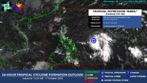
The low-pressure area located off the c ountry’s eastern coast has developed into Tropical Depression Ramil on Friday and is expected to make landfall on Sunday in Aurora or Quezon Province, the state weather bureau said.
“Its effect is not yet felt in any part of the country,” Grace Castañeda, weather specialist of Philippine Atmospheric Geophysical and Astronomical Services Administration (PAGASA) said in a 5:00 a.m. media briefing.
“However, this afternoon, as Tropical Depression Ramil moves closer, its trough or extension may bring scattered rain over the eastern portions of Southern Luzon and the Visayas.”
Ramil, the second tropical cyclone this October, was located 1,145 kilometers east of southeastern Luzon, moving west-northwestward at a slow pace.
It has a maximum sustained winds of 45 kilometers per hour (kph) near its eye, and gustiness of 55 kph.
During the forecast period, PAGASA has hoisted Tropical Cyclone Wind Signal No. 1 where strong winds are expected in more than a dozen areas in Luzon and the Visayas.
This covers areas, including the easternmost portion of Quezon, Camarines Norte, Catanduanes, Camarines Sur, Albay, and the northern and eastern portions of Sorsogon.
In the Visayas, it was likewise in effect over the eastern portion of Northern Samar, the state weather bureau said.
PAGASA also issued a heavy rainfall outlook, with 50 to 100 millimeters of rain expected on Saturday over Quezon, Camarines Norte, Camarines Sur, Catanduanes, Albay, Sorsogon, and Northern Samar.
The same amount of rainfall is also expected on Sunday over Ilocos Norte, Ilocos Sur, La Union, Apayao, Abra, Kalinga, Mountain Province, Ifugao, Benguet, Cagayan, Isabela, Quirino, Nueva Vizcaya, Aurora, and Quezon Province.
PAGASA said Tropical Depression Ramil is expected to continue intensifying over the Philippine Sea and may reach tropical storm category by early Saturday. — Edg Adrian A. Eva