

Typhoon Kalmaegi, locally known as Tino, is still expected to bring devastating winds and torrential rains to large parts of the country, and is expected to hit Northern Palawan by Wednesday morning, the state weather bureau said.
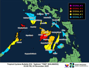
The typhoon, maintaining sustained winds of 130 kilometers per hour (kph) and gusts of up to 180 kph, was last located over the vicinity of Patnongon in Antique, the Philippine Atmospheric, Geophysical and Astronomical Services Administration (PAGASA) said in a 5:00 p.m. press briefing.
By early Wednesday morning, it is expected to reach the coastal waters of Linapacan, Palawan, and continue traversing until it exits over the West Philippine Sea.
PAGASA raised Tropical Cyclone Wind Signal No. 4 in several areas, which are expected to experience typhoon-force winds. This includes Calamian and Cuyo Islands in Luzon, and the central and southern portions of Antique and Iloilo, as well as Guimaras in the Visayas.
Signal No. 3, where storm-force winds are expected, is raised in the northernmost portion of mainland Palawan in Luzon, the rest of Antique, Aklan, Capiz, the northern and central portions of Negros Occidental, and the northern portion of Negros Oriental in the Visayas.
Meanwhile, Signal No. 2, where gale-force winds are expected, is hoisted in southwestern Masbate, the southern portions of Oriental and Occidental Mindoro, southern Romblon, northern Palawan including Cagayancillo Islands, Cebu, the central portion of Negros Oriental, and the rest of Negros Occidental.
Signal No. 1 is in effect in the southern portion of Quezon, southern Marinduque, the rest of Oriental and Occidental Mindoro, the rest of Romblon, the rest of Masbate, including Burias and Ticao Islands, central Palawan, Biliran, northwestern Leyte, Camotes Islands, northern and western Bohol, Siquijor, and the rest of Negros Oriental.
Following its multiple landfalls, Typhoon Kalmaegi has brought destructive winds and flooding, primarily in Cebu province, with floodwaters reportedly reaching above human height in some areas.
Several aftermath photos posted on social media show many homes swept away or dilapidated, with cars also carried off by floodwaters, some piled on top of each other.
The national disaster agency has yet to release an official report about the estimated cost of damage caused by Kalmaegi.
Cebu Governor Pamela S. Baricuatro said in a press briefing on Tuesday that clearing and relief operations are ongoing amid the typhoon. She also extended the suspension of work in all national and local government offices until Wednesday.
In Sagay City, Negros Occidental, one of the typhoon’s landfall sites, nearly 4,000 individuals are set to receive family food packs and other relief.
ANOTHER TYPHOON?While parts of the country are still inundated by floodwaters caused by Kalmaegi, a tropical depression has developed a few hours ago outside of the Philippine Area of Responsibility (PAR), with the possibility of it intensifying into a typhoon, according to PAGASA.
The cyclone, packing 55 kph sustained winds and 70 kph gusts, was located 1,900 kilometers east of northeastern Mindanao, moving 57 kph west-southwest.
It is expected to enter the PAR by Saturday, and the possibility of it making landfall in parts of the country is not ruled out, PAGASA said. — Edg Adrian A. Eva