

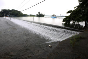
The La Mesa Dam has reached its spilling level, while the Ipo Dam is releasing water due to heavy rainfall brought by the Severe Tropical Storm Enteng and enhanced Southwest Monsoon (Habagat), the state weather bureau reported on Wednesday morning.
As of 8:00 a.m. on Wednesday, the water level at La Mesa Dam reached 80.20 meters, surpassing its normal level of 80.15 meters and causing an overflow, as the dam does not have gates to release excess water.
Residents in low-lying areas along the Tullahan River, including Fairview, Forest Hills Subdivision, Quirino Highway, Sta. Quiteria, and San Bartolome in Quezon City, are expected to be affected by the overflow of the La Mesa Dam.
Some areas in Valenzuela City, including North Expressway and La Huerta Subdivision, as well as the City of Malabon, are also affected.
“All the residents living in the aforementioned areas, especially those near the riverbanks, are advised to be alert to further increase of water level,” the Philippine Atmospheric, Geophysical and Astronomical Services Administration said in an advisory posted on Facebook.
Meanwhile, Ipo Dam has opened one gate with a 0.70-meter opening to prevent the dam from overflowing, as it is 0.51 meters away from its overflow level.
Ipo Dam is at 100.59 meters, nearing its normal high-water level of 101.10 meters as of 8:00 a.m. on Wednesday.
PAGASA has raised alerts for areas likely to be affected, primarily municipalities in Bulacan, including Norzagaray, Angat, Bustos, Baliuag, Pulilan, Plaridel, Calumpit, Paombong, and Hagonoy.
“Residents and the local disaster risk reduction and management councils (DRRMCs) concerned are advised to take appropriate actions,” PAGASA said.
For the other dams being monitored by PAGASA, here are the current and normal water levels, along with the difference from the normal water level as of Wednesday (September 4).
Ambuklao- 748.62 meters; 752 meters (Difference: 3.38 meters)
Angat- 189.17 meters; 210 meters (Difference: 20.83 meters)
Binga- 571.86 meters; 575 meters (Difference: 3.14 meters)
San Roque- 254.47 meters; 280 meters (Difference: 25.53 meters)
Pantabangan- 191.37 meters; 216 meters (Difference: 24.63 meters)
Magat Dam- 184.61 meters; 190 meters (Difference: 5.39 meters)
Caliraya- 287.28 meters (no data available for normal high-water level)
– Edg Adrian A. Eva