

THE record-smashing global heat of the past year has been driven partly by an El Niño weather pattern in the Pacific Ocean. The good news is that El Niño is rapidly giving way to his cooler sister, La Niña. The bad news is that she won’t necessarily be any kinder to humanity.
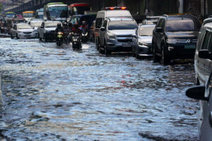
El Niño and La Niña are two phases of a local climate phenomenon, the El Niño-Southern Oscillation (ENSO), which influences conditions around the world. A strong El Niño in 2015-16 produced record high global temperatures, deadly droughts and floods, a spate of Pacific cyclones and the worst coral-reef bleaching event in history, to name just a few outcomes.
Though the now-dying El Niño of 2023-24 was one of the strongest on record, it was still notably weaker than that of 2015-16. But its global effects were even more alarming: 12 consecutive months and counting of global heat records, ocean water temperatures going to places where there are no charts, even more severe coral bleaching and more deadly droughts and floods. Why was this El Niño period so much more devastating, despite having less oomph? You get one guess, and the answer rhymes with “shlimate shange.”
Most simplistically, El Niño tends to make the world hotter, while La Niña tends to cool it. But the background temperature of the planet is now 1.3 degrees Celsius warmer than in preindustrial times, thanks to our enthusiasm for burning fossil fuels. That gives any El Niño a higher platform from which to wreak havoc.
Persistent global heating also makes it less likely that La Niña’s imminent arrival will bring much relief, if any. There is still a strong chance that 2024 will be the hottest year on record, even if half of it is spent under cooler La Niña conditions.
“The end of El Niño does not mean a pause in long-term climate change as our planet will continue to warm due to heat-trapping greenhouse gases,” World Meteorological Organization (WMO) Deputy Secretary-General Ko Barrett said in a release on Monday. The WMO noted the past nine years have been the world’s hottest despite several of them having been spent under La Niña conditions.
In fact, the Pacific Ocean’s ENSO pattern has been in a neutral or La Niña phase for more than 17 of the past 30 years, which has done little more than temporarily slow the inexorable rise in global temperatures.
Adding injury to insult, La Niña phases also tend to crank up the frequency of Atlantic hurricanes by dampening “wind shear,” or the change in air temperature as it rises or falls. Between a nascent La Niña and ocean temperatures that continue to be jaw-droppingly hot, scientists expect a summer and fall chock full of Atlantic hurricanes.
The National Oceanic and Atmospheric Administration recently predicted there could be up to 25 named storms and up to seven “major” hurricanes this season, which began on June 1 and continues until Nov. 30. Unfortunately, forecasters in recent years have tended to underestimate the number of storms that actually happen. And the hotter ocean water and higher sea levels produced by climate change tend to make hurricanes more intense and destructive.
It was bad enough during the centuries when El Niño and La Niña simply batted the global climate back and forth like a badminton birdie. Once humans got involved in manipulating the climate, they proved to be even more powerful and destructive, just on a longer time scale. The upside is that humans also have the power to change their impact, by transitioning away from the fossil fuels that are making the planet hotter. In the meantime, we must keep adapting to weather that keeps growing more chaotic no matter which side of the net the birdie is on.
BLOOMBERG OPINION